About
Interdisciplinary professional with a passion for environmental sciences, arts, and innovation. Her career has taken Margherita across five continents, working with people from various cultural, social, and environmental contexts. Through the years, she managed a diverse portfolio of projects, fostering public and private relationships, while growing her global network. In her spare time, she loves to play music, taking pictures, and travel around in search of inspiration.
Technological projects in 40+ countries:
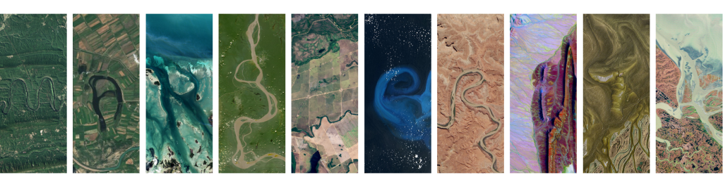
🚀 Management of global drone & Earth Observation projects and customers: satellite data, mapping, photogrammetry, 3D models, optical, multispectral, LiDAR & thermal data, data quality, standardization, and technical documentation. Sectors: forestry, change detection, monitoring, agriculture, renewable energy, water & climate risks, construction, telecom.
♻️ Consulting projects in Europe: climate risks & opportunities, carbon footprint / GHG emission accounting (scope 1, 2, 3), carbon emission reduction strategies, Life Cycle Assessments (LCA), soil & groundwater contamination, EU environmental and social regulations (EU Taxonomy, CSRD). Technologies: GIS/mapping, remote sensing, data analytics & visualizations (Power BI).
Timeline
Customer Success Manager 🛰️
Planet (remote – Brussels)
August 2025 – Present
Working in the Customer Success EMEA commercial team on:
- Using Earth Observation data to tackle global challenges and help organizations make smarter, faster decisions through satellite imagery and geospatial insights
- Managing and expanding customer relationships within different commercial segment: agro-chemical companies, digital agriculture startups, agro-insurances, climate risk disaster insurers, forestry, etc.
Consultant – Climate Risks | GIS | Data Visualization 🌍
ERM: Environmental Resources Management (Brussels)
February 2024 – August 2025
Working in the GIS/Data Visualization & Climate Change teams on:
- Climate risks and opportunities
- GIS, remote sensing, Power BI, data analytics & visualizations
Volunteer Web Manager 🌠
Women+ in Geospatial (remote, Brussels)
May 2024 – Present
The W+G Mission is to inspire, unite and empower, forging a geospatial community where all genders can thrive. W+G is building an inclusive global community to connect, support, empower, and enable all women+ in geospatial to become strong leaders and changemakers. The network drives gender equality in the growing geospatial community. As web manager, she’s in charge of assessing the current web presence of the community, propose strategic improvements and update web content.
Head of Drones 🚀
GLOBHE (remote – Luxembourg)
February 2023 – February 2024
As the leading drone data marketplace, GLOBHE leads organisations to make better decisions through accurate and actionable drone data while empowering local drone operators and companies.
- Team leader – Client Delivery (3 people department)
- Managing projects in 5 continents, ~40 countries & 4 languages (EN, ES, IT, FR)
- Drone operations & technical documentations
- Drone data processing, Quality Control, analysis, visualisation
- Clients/drone companies’ relationship & sales
- Working with UNICEF, FAO, World Bank, Red Cross
- Participating in humanitarian drone/emergency management working groups
Product Manager | Drone Operations 🚀
GLOBHE (remote – Luxembourg)
June 2022 – February 2023
As the leading drone data marketplace, GLOBHE leads organisations to make better decisions through accurate and actionable drone data while empowering local drone operators and companies.
- Managing projects in 5 continents, ~40 countries & 4 languages (EN, ES, IT, FR)
- Drone operations & technical documentations
- Drone data processing, Quality Control, analysis, visualisation
- Clients/drone companies’ relationship & sales
- Working with UNICEF, FAO, World Bank, Red Cross
- Participating in humanitarian drone/emergency management working groups
Earth & Geospatial Scientist | Drone Pilot 🗺️
RSS-Hydro (Luxembourg)
September 2020 – June 2022
R&D company operating across geospatial fields for a more sustainable future – using Earth Observation, remote sensing, drones, and computer models to achieve industry impact for a number of SDGs and to better inform decision-makers in meeting the Goals.
- Commercial drone/UAV operations (RGB, thermal, LiDAR sensors), data processing (photogrammetry, 3D modelling), Quality Control, analysis, visualisation
- Water risks & flood modelling with satellite imagery (LISFLOOD – 2D hydrodynamic model)
- Humanitarian projects in Africa. Geospatial solutions to simulate and monitor floods, droughts & climate change impacts along the Niger River Basin
- Participation to startup acceleration program Fit4Start
- Scientific publications & conferences
- Science communication (company website, videos, blogs & articles)
UN Volunteer ✍️
United Nations | UN Mappers | Humanitarian OpenStreetMap (HOT) (remote)
January 2021 – present
Contributing to scientific publications on climate change, forestry, hydrology and remote sensing related topics. Mapping remote areas of the world with HOT, supporting humanitarian activities for aid disaster relief, preparedness and economic development, and actively support Mapathons (UN Mappers).
- Mapping
- Earth Observation
- Scientific publications
- Community building
Community Representative for Luxembourg 📢
Women+ in Geospatial (remote)
January 2021 – May 2024
The W+G Mission is to inspire, unite and empower. W+G is building an inclusive global community to connect, support, empower, and enable all women+ in geospatial to become strong leaders and changemakers. The network drives gender equality in the growing geospatial community. As regional ambassador, she’s the single point of contact for regional and country-based activities, coordinating and leading a team of volunteers to organize networking events and activities.
- Feminism
- Human rights
- Inclusion
- STEM
- Community building
Contact
Reach out for interesting opportunities together.
Your message has been sent

